The world as we know it, or at least the way we view it on a map, is wrong.
Astoundingly, we’ve been viewing things incorrectly since 1569. That’s when Flemish cartographer Gerardus Mercator designed the “Mercator Projection” to help sailors navigate the seas. His creation was widely praised, thanks to its clean, straight lines for latitude and longitude and the way it preserved the relative shape of each country and continent.
Today, the Mercator Projection is still widely used in schools and is even the source for Google Maps. Yet there’s a lot about this map, and others, that is inaccurate.
Curious to see what maps get wrong? Let’s take a journey around the world and have a look…
North Dominates the South
Getty Images
Looking at most maps, the northern hemisphere takes up a larger share of the map than the south. Why? The equator splits Earth, which is a sphere, in half.
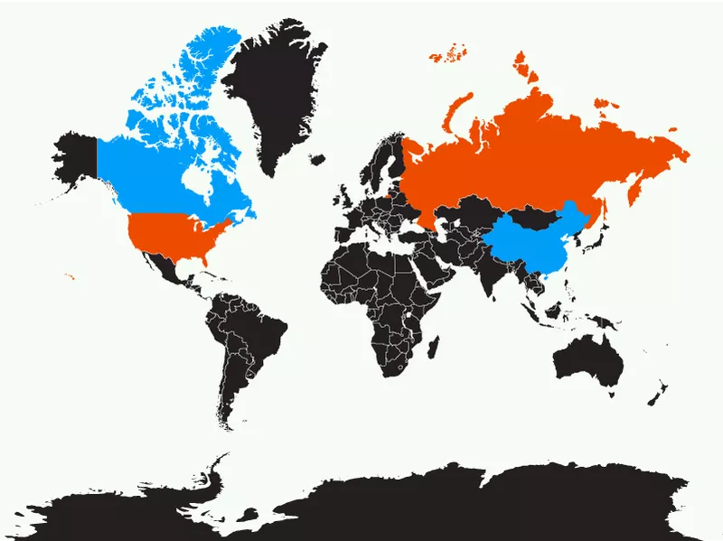
Pole Position: Russia vs. United States, Canada vs. China
Getty Images
While the Mercator Projection was praised for preserving the relative shape of each country, the same can’t be be said for their size.
Areas around the North and South Pole, such as Alaska, Canada, Russia, Greenland and Antarctica appear more stretched out than they are.
Let’s take a look at how they compare to other countries on the map:
Russia dwarfs the United States on the map, but is only two times larger. Similarly, Canada looks much bigger than China, but they are roughly the same size.
The real size of countries is mindblowing.
By the Numbers:
Russia: 6.6 million square miles (17 million KM2)
Canada: 3.9 million square miles (10.1 million KM2)
USA: 3.8 million square miles (9.8 million KM2)
China: 3.7 million square miles (9.6 million KM2)
Pole Position: Alaska vs. Mexico
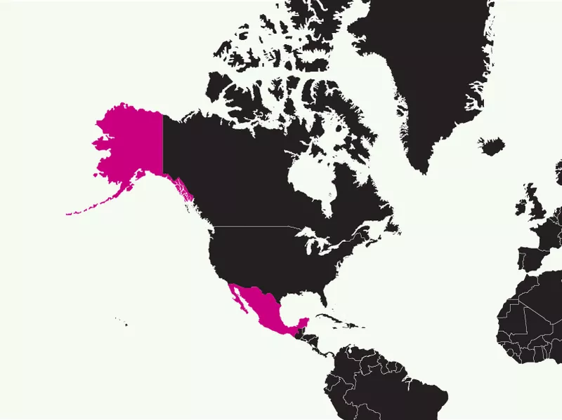
Getty Images
On the map, the state of Alaska looks bigger than the entire country of Mexico.
However, Mexico is 1.14 times bigger.
By the Numbers:
Mexico: 758 thousand square miles (2.0 million KM2)
Alaska: 663 thousand square miles(1.7 million KM2)
Pole Position: Greenland vs. South America vs. Africa
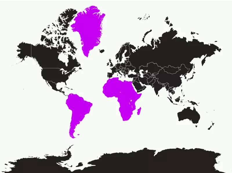
Getty Images
One of the biggest map blunders is Greenland, which looks larger than the entire continent of South America and comparable to Africa.
In reality, Greenland wouldn’t even cover Argentina or Algeria.
South America is more than 8 times its size, while Africa is an astounding 14 times larger than Greenland.
By the Numbers:
Africa: 11.7 million square miles (30 million KM2)
South America: 6.9 million square miles (17.9 million KM2)
Argentina: 1.1 million square miles (2.8 million KM2)
Algeria: 0.9 million square miles (2.3 million KM2)
Greenland: 0.8 million square miles (2.1 million KM2)
Pole Position: Antarctica vs. China vs. Brazil
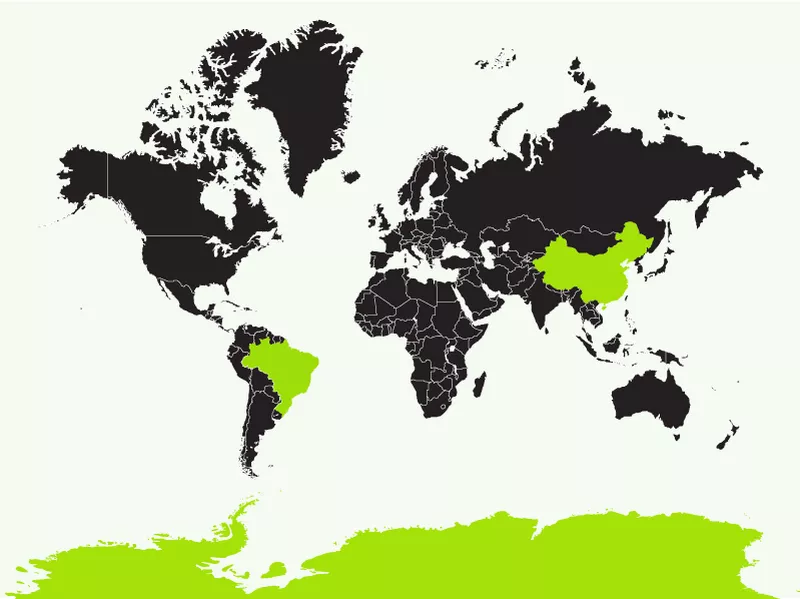
Getty Images
Antarctica, one of the world’s most undiscovered continents, appears absolutely massive.
Yet it is only slightly larger than the world’s largest countries: 1.6 times the size of Brazil and about 1.5 times the size of China.
By the Numbers:
Antarctica: 5.4 million square miles (14 million KM2)
China: 3.7 million square miles (9.6 million KM2)
Brazil: 3.3 million square miles (8.5 million KM2)
Europe Inflation: Europe vs. United States
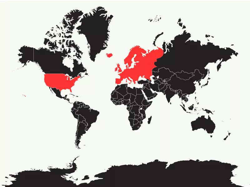
Getty Images
Another major criticisms of the Mercator Projection is that Europe’s imperialism played into how it was depicted. Similar to the countries around the poles, much of Europe appears larger than it actually is. For example:
Europe looks larger than North America, but the United States alone is almost as big, with 9,833,000 square kilometers to Europe’s 10,180,000.
By the Numbers:
North America: 9.4 million square miles (24.3 million KM2)
Europe: 3.9 million square miles (10.1 million KM2)
United States: 3.8 million square miles (9.8 million KM2)
Europe Inflation: U.K. vs. Japan, Madagascar and New Zealand.
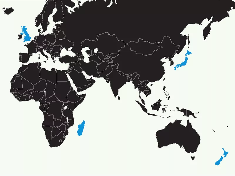
Getty Images
The United Kingdom stands out as mighty impressive, but it’s actually smaller than other islands around the world including Japan, Madagascar and New Zealand.
By the Numbers:
Madagascar: 226 thousand square miles (585 thousand KM2)
Japan: 145 thousand square miles (376 thousand KM2)
New Zealand: 103 thousand square miles (267 thousand KM2)
United Kingdom: 93 thousand square miles (240 thousand KM2)
Europe Inflation: Scandinavia vs. India
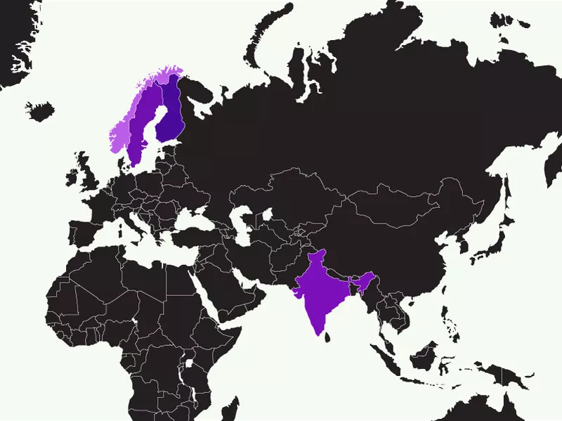
Getty Images
The Scandinavian countries of Norway, Sweden and Finland appear larger than India, the world’s 7th largest country.
In reality, all three combined would fit inside of India, and there’d still be room left.
By the Numbers:
India: 1.3 million square miles (3.4 million KM2)
Norway, Sweden and Finland: 0.45 million square miles (combined, 1.2 million KM2)
Shrinking Near the Equator: Africa vs. multiple countries
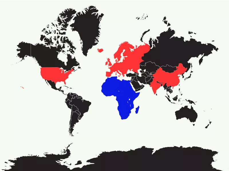
Getty Images
Though Europe and North America are sketched to impress, Africa, Australia and South America’s positioning near the equator has minimized them on the map.
Africa looks almost miniscule, but is bigger than China, India, the majority of Europe, and the continental United States — combined. It’s also 1.8 times the size of Russia and 3 times the size of Canada.
Like Africa, South America isn’t drawn to scale. Brazil, the world’s fifth largest country, is almost the size of Europe and the United States. It appears smaller than Alaska, but is actually 5 times bigger.
Australia is also much larger than it appears. If moved up on the map, it would be cover almost the entirety of Europe and the continental United States.
By the Numbers:
Africa: 11.7 million square miles (30 million KM2)
South America: 6.9 million square miles (17.9 million KM2)
Europe: 3.9 million square miles (10.1 million KM2)
Australia: 3.0 million square miles (7.8 million KM2)
Challenges, Distortions, and Attempts to Redraw the World

Searching for directions on our mobile devices, it’s hard to imagine a time when explorers relied on hand-drawn sketches to find their way. It’s also easy to forget that, despite technological advances, maps still have a long way to go.
As we’ve uncovered with the Mercator Projection and other examples, maps are filled with mistakes. But what are some of the reasons behind the errors?
Remember when you were in grade school and learned that people once thought the world was flat? Many cartographers probably wish that was true, given how hard it is to project a round, three-dimensional planet onto a two-dimensional piece of paper. This process, known as projection, compromises size, shape and distance.
Choosing One Element Over Others
As we’ve seen with maps, some preserve shape and relative distance but distort size. Even the greatest cartographers haven’t yet figured out how preserve all of the elements that go into a map. They may be able to factually depict one or more but will inherently sacrifice other details to do so.
More doesn’t always mean better. In order to show the world, or even a small portion of it, cartographers must display information at a reduced size. Sometimes that means cramming a lot of graphics, legends and symbols into a small area, making it hard to read.
Maps before Mercator
Long before Mercator, many other cartographers applied their skills to create maps that reflected their society and beliefs.
While also riddled with mistakes, they remain an important teaching tool. Let’s journey through the past and have a look…
Beyond Paper: Early Map Creations
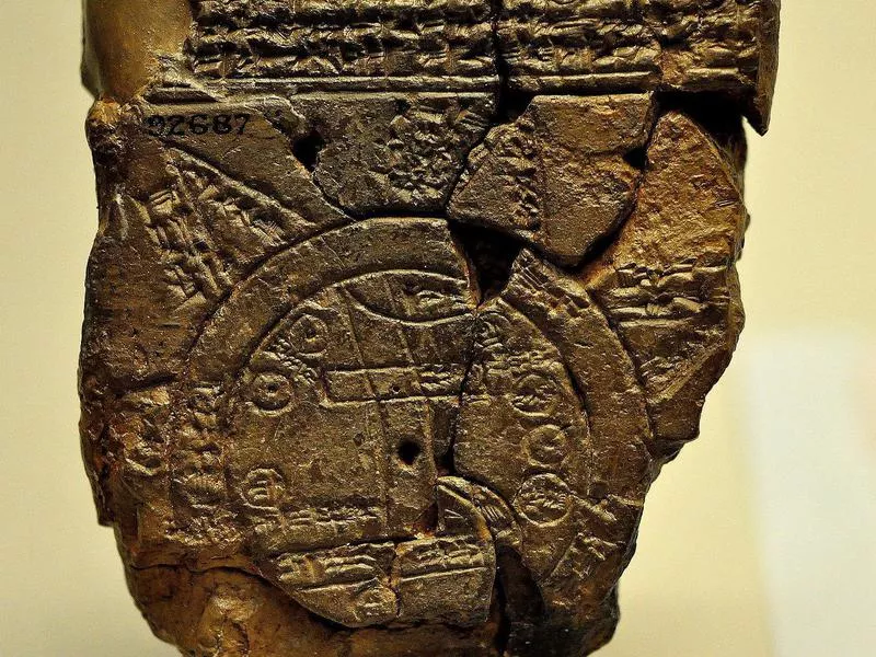
The Babylonian world map, probably from Sippar, Mesopotamia, 700-500 BCE, in the British Museum. Osama Shukir Muhammed Amin FRCP(Glasg) / Wikipedia Commons
Like great works of art, maps are unique, subjective and open to interpretation. One of the world’s first maps, a cave painting in Anatolia, Turkey, represents both map and work of art. Dating back to around 6200 BC, the ancient painting shows how homes and streets were positioned, and includes surrounding features such as a volcano. Though some claim it’s more of a painting than a map, the ancient creation contains the key elements of an effective map, including size, shape and relative distance.
Roughly 3,000 years before the first iPad, Babylonians carved a map into a tablet. This archeological treasure, which contains inscriptions and drawings that detail ancient Mesopotamia, is a great example of how a map’s inaccuracies can provide valuable insight into how society viewed the world. For example, the Babylonian’s belief that they were the center of the universe is reflected in how Babylon is positioned at the map’s center. Though geographically inaccurate, it was one of the first maps to include details such as mountains, rivers, islands, and other countries.
Math, Science and Geography
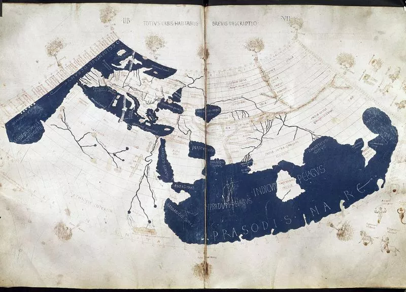
A 15th-century manuscript copy of the Ptolemy world map, reconstituted from Ptolemy’s “Geography.” Francesco di Antonio del Chierico / Wikimedia Commons
In 150 AD, a Greek scholar named Claudius Ptolemy combined math, science and the written word, creating a valuable textbook entitled “Geography.” The book described how to draw world maps using intersecting lines and introduced the concept of latitude and longitude. The book also plotted over 8,000 locations in Europe, Asia, and Africa.
Of course, even the “Father of Geography” was bound to make a few mistakes. Missing from his map are the Americas and a large chunk of the Pacific. Still, there’s no denying Ptolemy’s research and methods (rumored to be inspired by his work as an astrologer and obsession to plot where people were born) set the course for maps as we know them today.
Fun fact: Ptolemy played a hand in Christopher Columbus’ voyage to America. Ptolemy thought the world was about 30 percent smaller than it is. Using his map, Columbus expected his journey to Asia to be much shorter.
Blending Cultures, 1100s
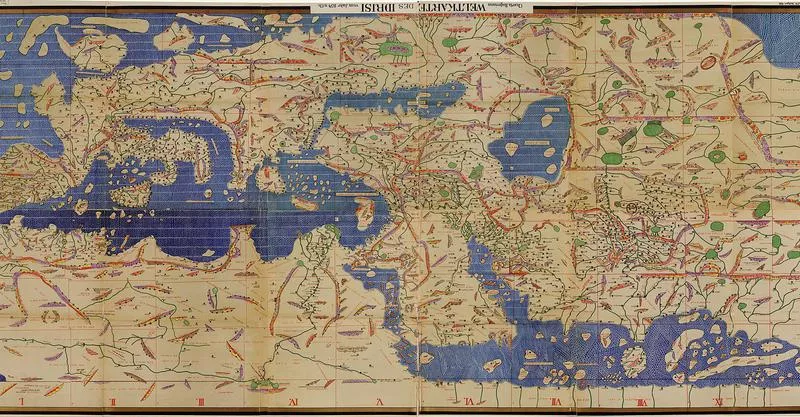
The Tabula Rogeriana, drawn by al-Idrisi for Roger II of Sicily in 1154, shown upside-down as the original had South at the top. Al-Idrisi / Wikimedia Commons
The fall of the Roman Empire brought a dry spell for geographical innovations, but that changed in 1154 thanks to Muslim scholar Al-Sharif al-Idrisi. A revered traveler, he was invited to live in the Sicilian court of King Roger II, where he created a geography guide that combined guide that combined Greek, Islamic and Christian teachings.
More accurate and detailed than Ptolemy, al-Idrisi was the first to introduce the importance of Northern Africa to the rest of the world. He also included recorded accounts of ethnic groups and socioeconomic factors and was among the first to proclaim that the world was round. Al-Idrisi was widely praised for his accomplishments, which inspired cartographers for years to come.
However, like many others, his maps were influenced by power and money, heavily focusing on King Roger’s land.
Herford’s Mappa Mundi, 1300s
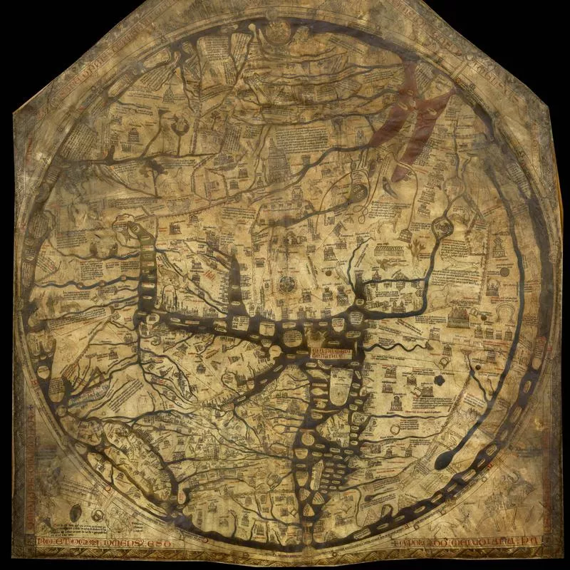
The Hereford Mappa Mundi, displayed at the Hereford Cathedral, England. Unknown / Wikimedia Commons
In medieval times, maps shifted from practical to symbolic. A famous example is a 1300 rendering by clergyman Richard of Haldingham.
Drawn on animal skin in Hereford, “Mappa Mundi” (a generic term for European medieval maps) wasn’t intended to get a person from point A to point B. Rather it puts Jerusalem in the center and features Christian images such as Adam and Eve and Jesus Christ, representing how important religion was at the time.
With images such as a lynx in Asia-Minor and Noah’s Ark in Armenia, Mappa Mundi is among one of the most unique (some may say strangest) maps ever created.
The Fra Mauro Map, 1400s
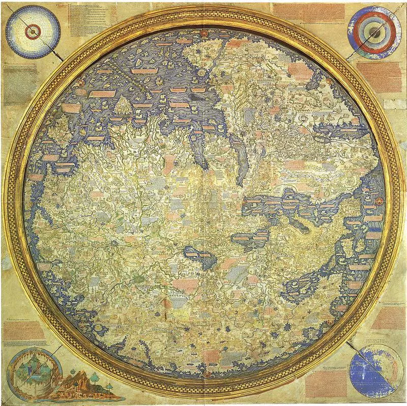
The Fra Mauro Map, depicting Asia, Africa and Europe. Piero Falchetta / Wikimedia Commons
One of the finest examples of medieval cartography, the Fra Mauro is a large round map that’s widely hailed as the most accurate map of its time.
Incredibly curious, Fra Mauro was a monk with wondrous cartography skills and a penchant for asking anyone who crossed his path in Venice to recount their world experiences. Mauro’s nosey questions paid off as he created a richly detailed map filled with pictures of jewels, exotic animals, and lakes of honey-wine. His map also stands out for its rejection of religious authority.
Unlike the Hereford map, he placed the Garden of Eden in a side box, not a geographical location.
The Birth of the Americas, 1500
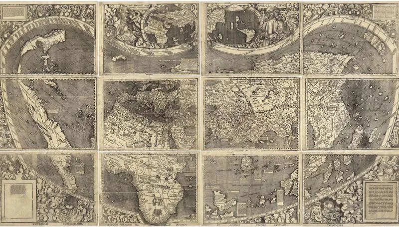
“Universalis Cosmographia,” the Waldseemüller wall map dated 1507, depicts the Americas, Africa, Europe, Asia, and the Pacific Ocean separating Asia from the Americas. Martin Waldseemüller / Wikimedia Commons
The first map to name the Americas and show the Pacific, Martin Waldseemüller’s world map changed the way maps were created.
Unlike maps that preceded him, Waldseemüller strived to keep up with discoveries in all areas of the world, not just his own. He was the first to cover 360° of longitude, show the complete coast of Africa, and show the Americas as a separate continent.
The map paid tribute to Ptolemy and was named for Amerigo Vespucci, an explorer who’d proved the Americas were indeed their own continent.
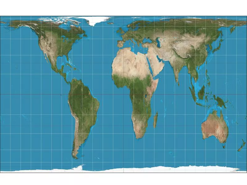
The ‘Other’ Maps: Gall-Peters Projection
The advent of the Mercator Projection in the 16th century was a giant advancement, but modern map makers have tried to solve, or counter balance, its distortions with alternative ways of depicting the world.
As famously shown on an episode of “The West Wing,” one such attempt, The Gall-Peters Projection, which was created in 1974, succeeds at showing the correct sizes of counties, but stretches their shapes.
The ‘Other’ Maps: Robinson
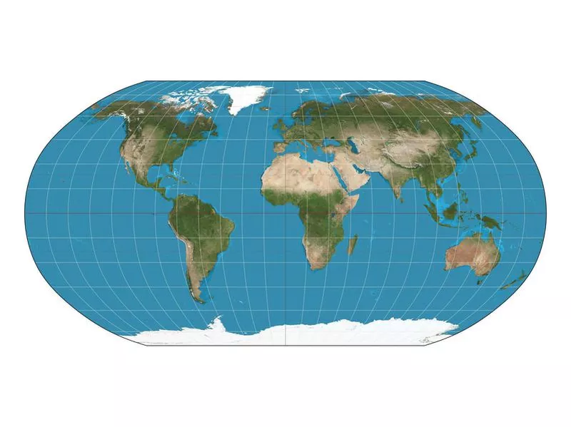
The Robinson map, created in 1963, improves on The Mercator. Strebe / Wikimedia Commons
The Robinson, created in 1963, improves on the Mercator by making Greenland, Russia and Canada more scaled to size.
However, the spacing between continents is off and areas around the poles remain distorted.
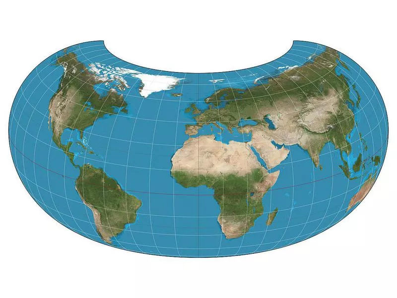
The ‘Other’ Maps: Armadillo Projectio
The 1943 Armadillo Projection attempts a 3-D simulation with a torus. Here, continents are shaped well but the oceans appear smaller than they are.
Also, areas on top and on the sides are distorted, half of Australia and all of New Zealand is cut off.